Category: Favorite hikes

South Old Woman River Trail

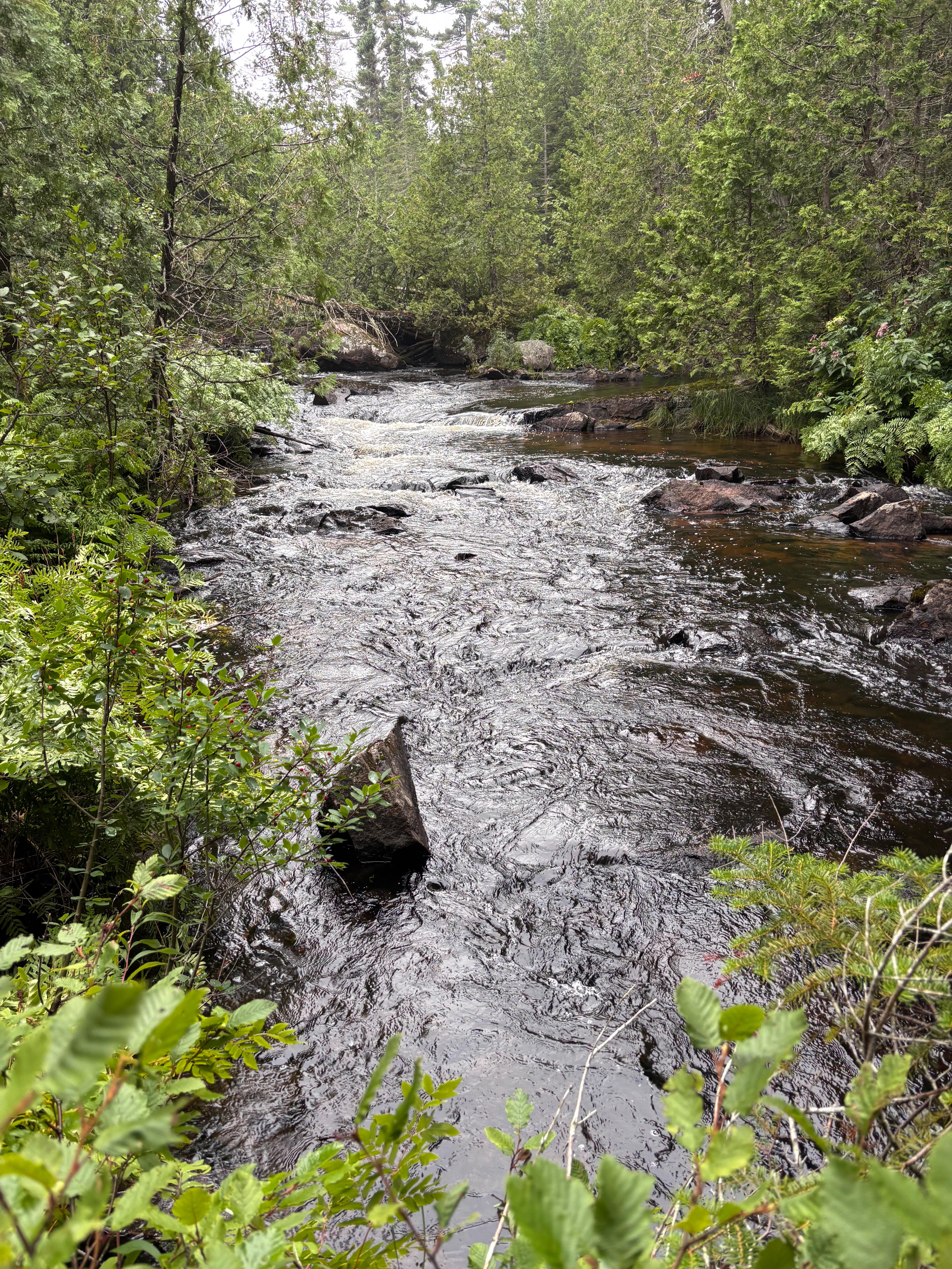
August 16, 2025 at 4:47 PM

Opting for an easy hike this morning, we chose the South Old Woman River Trail, rated 4.4 and easy. My hip was sore from the last few days hiking, so easy for an hour and a half sounded good. The hike starts across 17 from the campground, so we walked from the campsite. 

Reproducing Kelly’s picture of the Trans-Canada Highway

The South Old Woman River flows out of Rabbit Blanket Lake, under 17, the Trans-Canada Highway. I was anxious to see it. Darkness took over as we entered the forest. Trees sent roots everywhere, across the path, over rocks and into pools of water. Frogs and chipmunks greeted us at every turn. When we didn’t see them, we saw where Squirrels or chipmunks had eaten, leaving shells from seeds covering the path or tree stumps. 

There were holes all over the place, leading to where I don’t know, but I was cautious stepping between roots where my foot might go through to God knows where. Who lived in all those holes? Chipmunks? Squirrels? Some were big, and stepping around them made a hollow sound. Were there underground tunnels? Several were huge, where bears might sleep. I decided this was a forest where gnomes might live. 

The river is gorgeous, whether you are a fisherman or not. It is tea-stained so I couldn’t see any fish, but it is cold water, and I know they are there, because the sign said this was great brook trout fishing. It was so hard to step between all these roots and still get a look at the stream. Make a bad step into a gnome’s hole and you might sink to your hip. 

We crossed the stream several times, but one was rather threatening. Huge boulders with flat tops led across the rushing river, but first we had to sit on our buts and slide our foot to a sharp-angled rock and then climb up the the first flat boulder. A mistake there and it’s trouble, especially for people in their late 70’s. 

The trail makes a lollipop loop at the top so we can see a beautiful waterfall plunging into a big pool below. I was picking my spots to fish….if I could get to them. It was tough conditions to fish, but that might mean there were lots of wily Brook Trout.

At the end of the lollipop loop, we stepped cautiously back toward our origin. I took pictures of plants and flowers on “PictureThis” app, to determine what they were, but I had no cell service – another reason to think there were gnomes here. I love the app, because it identifies the plant and tells you if it is edible or medicinal or just pretty, or you want to plant in your yard. Some were poisonous to people and pets, but then I have never seen a Labrador retriever eat red berries or mushrooms.

I was soaked in sweat when we got back from this easy hike rated 4.4, but right off the bat, I would rate it a 5.0, moderate. It is so unique and travels next to a gorgeous trout stream that is difficult or impossible to fish, which just piques the imagination. And then there are the gnomes living in those holes, a rushing stream underground that you can’t see, but only hear, and trees growing right on top of giant boulders.

Probably someone’s dog, but they don’t allow dogs on the trails and there are no claws on the prints
Moose poop, like chocolate-covered almonds

After a shower and lunch, we drove 33 miles to Wawa, one, to see this beautiful country of one gorgeous lake after another, and beautiful, rushing rivers feeding into Lake Superior. The other was we needed propane, and to fill up with gas.

We stopped at the mouth of the Old Woman River where Kelly caught two beautiful steelhead 12 years ago. People were sitting on the beach eating lunch and enjoying the scenery. I remember walking upstream past Kelly, across a little peninsula and seeing tracks and scat that made me realize we were not in Kansas any more. I made a quick retreat back, where Kelly was trying to protect his two fish from ravens trying to steal them. 

I peered around the corner to see the rivers. It wasn’t rushing so hard, but giant trees were strewn across sandbars just to let you know how powerful this river can be.

We came to Wawa, which is more like an outpost on the edge of a frontier. Businesses had come and gone, yet the town of 2,000 pushes on. Carvings of giant Canada Geese are the trademark of the town. This is a place to stock up and fuel up before heading out into the wild to fish, hunt, photograph or explore. It is nice to know there still are such places, making me wish I was younger.

The only propane refill place in town is not open on weekends. With all these campers and cabins, I can’t believe we couldn’t find propane on a Saturday. We have another tank, so it isn’t urgent, so we’ll come back next week. We drove through town to find Silver Falls on the Michipicoten River. We continued up a wide, well-maintained gravel road to find Long Beach. We didn’t go down, but we could see people swimming and having a big time on a cool 68 degree day.

Silver Falls
Overlook of Long Beach, Lake Superior

Back at camp we opened a bottle of wine, built a fire and cooked hamburgers over it. Maybe tomorrow maybe we’ll go see the pictographs.

New trick I discovered for writing the blog. All HEIC pictures from iPhone have to be converted to JPEG before I can upload them to WordPress. A video, (https://www.google.com/search?client=safari&rls=en&q=what+is+the+best+way+to+convert+HEIC+pictures+in+bulk+to+JPEGs&ie=UTF-8&oe=UTF-8#fpstate=ive&vld=cid:f315e512,vid:WQcYYPJ8NFo,st:64) told me to go to Photoshop, File, Scripts, Image processor. Then select the folder where you want the pictures, check save to same folder, choose the quality you want and the format – JPEG, push Run. The second time is much faster since the same settings come up. Just change the folder. Saves a LOT of time.

Hike Petroglyph Trail in Mesa Verde National Park

Thursday, August 4, 2022

One of the coolest hikes we have been on, we enjoyed this one a lot. What makes a great trail? A great view, features along the way, discovery of something new, history, wildlife, solitude all go into making a great trail. This one has some great features, steps (some carved in rock), slots between huge rocks, walking under shelves where people have walked for thousands of years. The petroglyphs were a special attraction. There were a few others on the trail, but not many. We were reminded of the history of this place passing a wall still standing from a house built 900 years ago. Toward the end you climb up out of the canyon onto the mesa top and walk along a gravel path that leads back around to the museum. It crosses what was once a great, flowing stream with a waterfall into the canyon right in front of Spruce Tree House, one of the great ancient ruins of the park.

Petroglyph Point Trail
Difficulty: Strenuous  
Distance: 2.4 miles (3.9 km) roundtrip  
Elevation Change: 227 feet (69 m)
Trailhead: Spruce Tree House Overlook, by the Chapin Mesa Museum

A rugged and adventurous trail with steep drop offs. Hikers traverse the side of Spruce Canyon, squeezing between boulders and descending narrow stone staircases to reach a large petroglyph panel at 1.4 miles (2.3 km). From here, hikers must climb a 100-foot (30 m) cliff, scrambling up rocks and uneven sandstone steps to the mesa top, before returning through pinyon-juniper forest on the mesa top to complete the loop.

Hike Pueblo Alto, Chaco Culture National Historic Park

Sunday, July 31, 2022

Our goal was to hike Pueblo Alto Loop Trail, which is about 5.5 miles on top of the north mesa to another settlement, Pueblo Alto. Continuing across the mesa and around the rim with views of the valley, Pueblo Bonita, Chetro Ketl and Chaco Canyon. 

People have been here for thousands of years, but in the mid-800’s they began to build on a grand scale for 300 years, and it is incredible what they did. It became the hub of trade for settlements throughout the southwest and Mesoamerica, bringing chocolate here. They built roads to connect settlements, irrigated fields, stored water and foods and had ceremonies in their great, round kivas. Many Native Americans feel this was where they came from, and it holds great spiritual value to them. To build such a structured society, there had to be strong leadership and organization. 

The trail starts behind Kin Kletso, one of seven major “great houses”. It quickly climbs up the mesa through a very narrow slot in the canyon wall. Once on top, it is mostly level with wonderful views of the settlements and the large valley. A mile around the rim, we had a great overlook of Pueblo Bonito. It is like a highway on the solid rock of the rim, the trail well-marked by cairns (rock piles). In Canada they are called Inunchucks, the Inuit name for their way of marking sites or trails on the ice.

It was a beautiful morning, beginning at 65 degrees. I almost wore a second shirt, but knew I would soon warm up. It was overcast, a blessing in July in New Mexico. Martha and I rate this the best hike we have taken. It was a perfect day for hiking; we never saw anyone else; the history is amazing, comparable to Machu Picchu; there are many unique features: solid rock canyon rim extending for miles like a highway, slot canyons, canyon steps carved 1,000 years ago, the views, “buckets” holding water, iron deposits. There were very few boring steps. Wonderful hike, and it was the ranger’s second favorite! I think her favorite was the Petroglyphs Trail, but the wash was running too hard to cross.

Canyon Overlook Trail, Zion National Park

Friday, July 15, 2022

On our last day with Karen, Josh and Melissa, we drove north through the tunnel to hike the Canyon Overlook Trail, the shortest hike in the park that provides a view of the canyon. It has some unique features that keep it interesting, but the views are spectacular. 

People were lined up to come up as we were going back down. It’s a very small parking lot, so a lot of people park along the road, which makes driving hazardous. 

Martha asked me recently what my favorite park has been on this trip. I don’t know that I have a favorite. They are all spectacular in their own way, or they wouldn’t have become a national park, but Zion has to be the most photogenic! 

Back at camp, Karen and the kids packed up, and we drove to St. George Regional Airport. It’s a small, but very modern airport. Karen said no one was at the counter when they went in, but it all worked out, and they arrived home the next morning safe, but very tired. 

At 5:30 PM

Emerald Pools Hike, Zion National Park

Wednesday morning, July 13, 2022 

You cannot drive on the Scenic Drive, so we took the bus. They come every five minutes or so, and are very efficient and polite, often giving the weather report and offering advice for the each stop. Zion is a very busy park, but they do a wonderful job of managing it.

We got off at the Court of The Patriots, where magnificent mountains surround a small cove. Then we set out to hike the Emerald Pools Trail. The pools weren’t in their full splendor, but the scenery was magnificent. I took a video of a showering, 200′ waterfall, but it requires more data than I have on my phone to upload. I put this on my “Favorite Hikes” list. With a waterfall (and another when it rains), pools and spectacular scenery, what better way to spend a couple of hours!

Little Wild Horse Canyon, Utah

Wednesday, July 6, 2022

Just outside Goblin Valley State Park is Wild Horse Canyon, which can be a four-mile or eight-mile hike. We opted for the four-mile, which meant we would hike up the slot canyon until it meets a gravel road, then go back down. A sign warned to check weather before hiking. Flash flooding can put you in danger in a slot canyon. “Be aware of your escape route.” Capitol Reef National Park had big flooding issues three weeks ago. Six people had to be rescued and 60-80 people were stranded in a parking lot.

Although an incredibly beautiful storm came through last night, there was nothing expected today, and it was a beautiful morning. It starts out walking up a dry stream bed. We talked with an experienced family with three small children, who said the forecast was good. They were obviously experienced hikers with all the right gear. The husband had climbing gear and a rope over his shoulder. I felt good following them, but when we stopped to photograph a few lizards, they were gone. I’m pretty sure they were doing the 8-mile loop and would come down the slot canyon on their way back.

As the canyon narrowed from 60 yards to four feet, to 3 feet, we had to negotiate rocks and puddles of water. Once we surrendered to getting our feet wet, it became easier, but still challenging. Karen and Nathan are tremendous athletes and the kids are too. Melissa, usually silent until after noon, was leading the way, talking and laughing the entire way. I couldn’t help but laugh. She is a gymnastic star and cheering team member with strength and flexibility that are incredible. She was playing a Disney star describing the challenges presented.

As with most hikes, Martha and I were glad to get to the top, but already wondering if going down would be even tougher. Fortunately it was easier. I think everyone rated it one of their favorite hikes. It was pretty, challenging and very different. I kept looking for mountain lions or goats, but never saw anything. Karen, however, spotted several pronghorn on the way to the hike.

Arches National Park

We were up early, so we grabbed some things and drove north 10 minutes to Arches National Park. The park is so busy, you have to reserve an entrance time between 6:00 am. and 5:00 pm. We got there at 5:30, showed our National Parks Senior Pass and drove right in. There were others in front and behind. 

It’s about 12 miles to Delicate Arch trailhead, the featured attraction of the park. It’s hard to zip along, because the scenery is so spectacular. It was a beautiful morning with some cloud cover, a perfect morning for a hike.

The hike is 3 miles round trip, rated moderate. It’s a cool hike with incredible scenery. A pretty girl with a nice camera was walking out. I asked her if it was still there, and she said, “It is, but the sunrise isn’t.” I smiled and walked on. I guess we were about an hour late. The last stretch is along a cliff, which I do NOT like, but we made it. I could see why this is #1, as it is unique and very pretty. 

On the way back out, we took a short side trail to some pretty spectacular petroglyphs made by the Ute Indians, for whom the state of Utah is named. 

We stopped for a picture of Sand Dune Arch. Then we drove through the campground. It’s a very cool campground. Two sites had spectacular views of the valley below. One in particular looked so cool. A young lady was making breakfast with that view in front of her. There are also some nice picnic areas near the campground.

Then we went for a 1-mile hike to Landscape Arch. By now the parking lots were filled and the trail busy, but not really a problem. People watching is also fun. There were lots of young children, some not looking so happy. One very fit mother was carrying an infant on her back and holding the hand of a young girl. 

There are 2,000 arches in the park! The landscape changes dramatically with different shapes, vertical walls that seem to have been cut with a laser. I envisioned riding a horse through a gorgeous valley below. 

By 9:30, I was tired and sore and now hot. This is a good time to be finished, although the crowds were still pouring in. At the entrance cars were lined up for a quarter mile in two lanes.

Back at the trailer it was well into the 90’s, a good time to finish my projects. I finally I realized I had to go back under the sink and rotate the base 180 degrees and turn the handle around. Voila! It all worked! We have water 😊. As a bonus, the sprayer worked – not great, but it worked. There is a little spring with a plastic basket that goes in the line under the sink, but I couldn’t figure out how to place it, so I left it out.

On to the reading light. Trying to solder a dangling light proved a challenge. With Martha’s help, we tried a few times, but managed to just end up with a big ball of solder that didn’t hold. Finally, I saw how to remove the little on/off switch, which made access better. I cleaned off the solder, and while I held the the wire to the switch pole, Martha held the solder in her left hand, soldering iron in the right, and working between my two hands holding the wires, she soldered it! How she managed to not burn our fingers or touch the other pole, which would have blown a fuse or worse, is amazing, but she did it! 

We screwed the light back in its hole, turned it on and it worked! Yahoo! It was a good day. I put all my tools back in the truck and cleaned up. It was 105 degrees outside, and pretty hot inside. The air conditioner runs all day, and never catches up during the day. We both considered that. God help us if that thing dies! We turned it off for a while and sat outside. Oddly, sitting in the shade with a little breeze is fine. A dip in the pool also helps, but by the time we walked back to the trailer in the sun, we were hot again.

We took Bob to dinner at his favorite pasta place and enjoyed further conversations. He had ridden his bike all through town this morning and found the trail with a line down the middle goes all the way through town, a street behind Main Street. This will give Karen even more distance to run when she comes. He said all side roads just lead to developments, although several were very nice. 

We drove up the side of a mountain to Sunset Grill to see what the view was like. It was pretty spectacular. We could see the whole town, and for the first time to realize the town sits in a valley. It is also bigger than how it seems when you drive through it. Bob heads out tomorrow for Montrose, Colorado. Maybe we can visit later down the road.

error: Content is protected !!