Author: Greg

Greg is a VMI ,MCV and Ohio State graduate. He is a retired prosthodontist (a dental specialist) who enjoys traveling in the Airstream, fishing, national parks, photography and just being outdoors. He rode horses most of his life and loves being around them. He is married to the lovely Martha. Greg and Kelly have been friends since we were 15 years old. Disclaimer: I get no money, kickbacks, rewards or any other favors from anyone.

Bandelier National Monument

Wednesday, August 24, 2022

64 deg at 4:00, high 79

One-hour drive from Santa Fe is Bandelier National Monument. Signs said to turn back and take the bus, but we pressed on. There is a campground just past the gate, so we knew we could get in. 

Martha, again selected an excellent camp site, so I signed up for three nights. With my Senior Pass, it cost $18! After setting up, we drove to the Visitor’s Center, hoping we could park. An overlook gave us a good look at the beautiful canyon. Then winding down a steep road to the bottom, we did find parking places. 

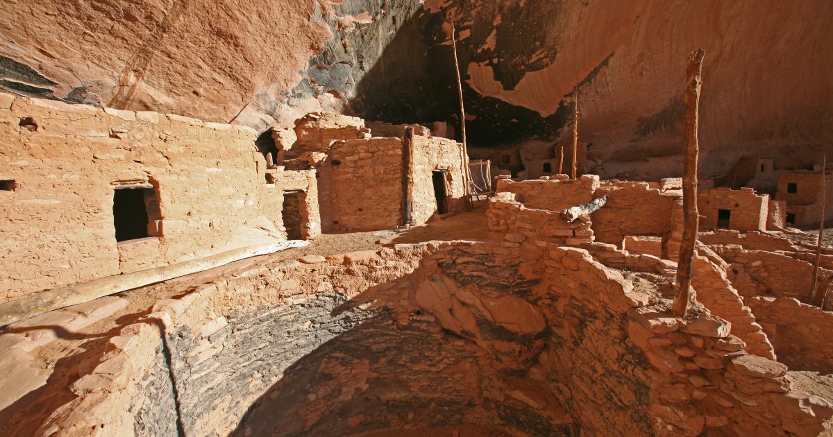
Built in the style of the ancient pueblos, the Visitor’s Center is very cool. Inside were good exhibits of the 33,700 acre park and main dwellings. People have lived here for 10,000 years. With a good stream, that rarely runs dry, the land provided well for them. 

There are some unusual features of this area. The main dwelling was huge, and it was on the canyon floor. Behind the main dwelling are cliff dwellings and Long House. A million years ago, a volcano exploded nearby, spewing ash heavily in this area. It was 600 times more powerful than Mount St. Helens. Over time, the ash solidified, pumice being its main component. Wind and rain dissolved holes and caves in this “Tuff”. The ancients carved caves for food storage along the cliffs. Just when you think you have seen it all, this strange landscape presents something so unique, it looks like a movie set.

It was very cool to walk along the cliffs and climb up ladders into the caves. One passing lady said, “You never hear of this. You hear fo the Grand Canyon, but who knew about this? It’s so cool!”

Then a man and his family passed. “Christopher Newport” was on his T-shirt, so Martha said, “Christopher Newport! I’m from Hampton.” She said she went to Hampton High School. “Oh”, he said. “Was Mike Smith the football coach?” She said he was. “Well he is still coaching! I will be working with him in the fall.” Amazed, Martha said to tell him Martha from 1968 said Hi. “I was a cheerleader.” I asked her to give us a cheer “You can’t crush a crab”, but she didn’t. 

We stopped at the little restaurant, where they touted their famous hamburgers and bison burgers. A young man named PJ was working the place all by himself, doing the cooking, taking orders and cleaning up. He was a wonderful cook! There is a nice store with some local Indian arts for sale as well as books and souvenirs. We bought a couple of cards to send the kids. As we walked across the parking lot, our Christopher Newport friend yelled, “Can’t Crush a Crab!” 😀 Back at camp, for the first time on this trip, we built a fire in a great fire pit. Should be an interesting three of four days.

First campfire of the trip on a cool evening
In back of our campsite

Santa Fe Historic District

August 23, 2022

65 deg at 6:00, high 78

We have been passing the Pantry Restaurant every day, and there are always people sitting on benches outside, waiting to get in, so we went in for breakfast. Martha ordered an omelette, while I ordered sausage and eggs and blue corn cakes with a hint of cinnamon. The coffee was very good, the service excellent and the food very good. 

We returned to the Farmer’s Market for a quieter Wednesday edition. Sadly, the chicken pot pie people weren’t there, but there were plenty of fruits and vegetables. 

World’s best corn salesman with a joke for every customer

Now that the Indian Arts Festival was gone, we wanted to explore old town Santa Fe. A sign noted the end of the historic Santa Fe Trail. Another marked the end of the old Spanish Trail. As we have learned, the Indians have been using these routes for centuries.

From United States National Park Service-Map, Robert McGinnis-illustration, https://maps.lib.utexas.edu/maps/national_parks/santa_fe_trail94.jpg

“Between 1821 and 1880, the Santa Fe Trail was primarily a commercial highway connecting Missouri and Santa Fe, New Mexico. The route was pioneered by Missouri trader William Becknell, who left Franklin, Missouri in September 1821. Others before him had been arrested by Spanish soldiers once they neared Santa Fe, and most had been hauled south toward Mexico City to serve lengthy prison sentences. Becknell, however, was pleasantly surprised to find that Mexico had overthrown the Spanish yoke, and the new Mexican government – unlike their predecessors – welcomed outside trade. Not surprisingly, others got into the trade soon after Becknell returned, and by 1825 goods from Missouri were not only being traded in Santa Fe, but to other points farther south as well. Some traders used the so-called Mountain Route, which offered more dependable water but required an arduous trip over Raton Pass. Most, however, used the Cimarron Route, which was shorter and faster but required knowledge of where the route’s scarce water supplies were located.

From 1821 until 1846, the Santa Fe Trail was a two-way international commercial highway used by both Mexican and American traders. Then, in 1846, the Mexican-American War began, and a few months later, America’s Army of the West followed the Santa Fe Trail westward to successfully invade Mexico. After the Treaty of Guadalupe Hidalgo ended the war in 1848, the Santa Fe Trail became a national road connecting the more settled parts of the United States to the new southwest territories. Commercial freighting along the trail boomed to unheard-of levels, including considerable military freight hauling to supply the southwestern forts. The trail was also used by stagecoach lines, thousands of gold seekers heading to the California and Colorado gold fields, adventurers, missionaries, wealthy New Mexican families and emigrants.

In 1866, just a year after the Civil War ended, an unprecedented period of railroad expansion began in the new state of Kansas. Within two years, rails had been laid all the way across central Kansas, and by 1873, two different rail lines reached from eastern Kansas all the way into Colorado. Because the Santa Fe Trail hauled primarily commercial goods, this railroad expansion meant that the trading caravans needed to traverse increasingly short distances. During the early 1870s, three different railroads vied to build rails over Raton Pass in order to serve the New Mexico market. The winner of that competition, the Atchison, Topeka, and Santa Fe Railroad, reached the top of Raton Pass in late 1878. Additional track mileage further shortened the effective distance of the Santa Fe. Then, in February 1880, the railroad reached Santa Fe, and the trail faded into history.” From https://www.nps.gov/safe/learn/historyculture/index.htm.

“Originally a Spanish town with a presidio surrounded by large defensive walls that enclosed residences, barracks, chapel, prison and the Governor’s palace. It was at the end of El Camino Real, the Spanish Royal Road from Mexico City.” (https://en.wikipedia.org/wiki/Santa_Fe_Plaza)

The old town is very pretty, in pueblo style with a Spanish square and beautiful Cathedral of St. Francis of Assisi. It is still a center of trade, art and cultures. I loved walking through some of the art stores, where there are incredible works. Paintings, sculptures, pottery, jewelry and baskets of the highest quality are displayed. In shop after shop, I was amazed, and I probably didn’t see  20% of them.

We had a nice lunch at The Burrito Company, sitting outside, across from the New Mexico History Museum. After lunch we went into the museum. With less than an hour on our parking ticket, we moved through, concentrating on the Indian art and discovery, passing up the wars and Santa Fe Trail. It expanded our already high opinion of Indian art from the festival. The work today has the advantage of modern techniques, but to see what they made in the 1200’s is amazing. 

I don’t know why, but walking around like this is very tiring. I tried to compare it to a hike. I know we haven’t walked as far as our hikes, and it certainly is on level ground. Maybe it is all the visual intake that makes you tired, but we had enough by 3:00. We left a lot unseen, but we also took a lot in.

Dale Ball Trail

Monday, August 22, 2022 

We took this 4.4 mile out and back hike that goes beside an old irrigation duct and the old reservoir. It was a very nice hike with great views at the top of Santa Fe. After being in so many small towns, it surprising to see Santa Fe covering the whole valley. 

Santa Fe Indian Market

August 2021, 2022

60 deg at 6:00, high of 72, rained most of the day

We came to Santa Fe because Martha’s friend, Carla, had talked so much about it. She and Marshall have been coming to the market for 25 years. They have participated in the organization and judging, and know many of the artists who come. But first, we went to the Farmer’s Market, A little rain didn’t seem to slow the regulars. It’s funny how people stand in line for a particular stand, when others seem to be selling the same thing. Martha loves a farmer’s market!

Dancing in The Rain

We met Carla and Marshall for lunch at The SantaCafe. Also joining were Carley, their granddaughter and Bob, an art enthusiast and avid fisherman. Bob talked about fishing several streams, but one stuck with me in Valle Caldera.

After lunch, we toured the booths. There are hundreds of them, where Indian artisans from all over come to display their work. They can submit work to be judged in one many categories, the winners getting a lot of notoriety. Collectors also come from all over the world, seeking out the best. Then there are thousands, like us, who have come to look and see what it is all about. this year was the 100th anniversary

It’s a bit overwhelming, so it was interesting to follow Carla and Marshall and listen to their comments. They know so many of these artisans and are greeted with smiles. We came back again the next day. It was a pretty day, which made it more pleasant to walk around. People were lined up for favorites of corn and fried bread. 

Sedona, AZ to Santa Fe, NM

Friday, August 19, 2022 

It’s a convoluted drive out of Sedona. You have to drive south, then east to I17, then north to I40 east. On Monday I had taken my truck to Flagstaff for an oil change. I drove north on 89A, which is a beautiful road, but it is a winding, narrow mountain road up and out of the canyon. There are tourist destinations all along this road, and it is also busy with local traffic. Workers and people are going to and from Flagstaff. It was a tough drive in the truck and NO place to pull a trailer! Going this way makes the drive about 8 hours if you don’t stop, and we stopped.

I40 in most places is Rt. 66. I had bought a book about Rt. 66, thinking we might drive parts of it. When Winslow, Arizona came up on a mileage sign, we had to make the turn! Martha was not familiar with the Eagles classic, “Take it Easy.”  I was ready for a cup of coffee anyway, so we took the exit.

Well, two blocks of Winslow make the best of the famous spot. I will never forget the place I first heard the song. I was in graduate school at Ohio State, working in the lab one evening. Mike Majchrowicz, standing on a lab bench against the wall, said, “Hey Dude, listen to this song!” He played it, emphasizing the lyrics, ‘Take it Easy’”. I guess I was being too intense.

The story of the song was also pretty cool. It would be the Eagle’s first hit. From https://americansongwriter.com/behind-the-song-the-eagles-take-it-easy/

“Singer-songwriter Jackson Browne began writing the breezy traveling tune in 1971 but couldn’t quite finish it. Then living at 1020 Laguna Avenue in Echo Park, Los Angeles, along with Glen Frey and J.D. Souther, he had been plucking away on his piano. Frey, who was sharing a one-room apartment for $60/mo, heard Jackson in the basement directly beneath him working on an early version.

“He had his piano and guitars down there. I didn’t really know how to sit down and work on a song until I heard him playing underneath us in the basement,” Frey noted in album liner notes. “I had never really witnessed that sort of focus – someone being that fastidious – and it gave me a different idea about how to write songs; that maybe it wasn’t all just going to be a flood of inspiration. That’s when I first heard [this song].”

“Take It Easy” was originally intended for Browne’s own self-titled debut album (1972), but he shelved the piece. “It was Glenn who remembered the song from some time earlier and asked Jackson about it one day,” said band member Don Henley.

Frey continued, “I told him that I really liked it. ‘What was that, man? What a cool tune that is.’ He started playing it for me and said, ‘Yeah, but I don’t know – I’m stuck.’ So, he played the second unfinished verse and I said, ‘It’s a girl, my lord, in a flatbed Ford, slowin’ down to take a look at me.’ That was my contribution to [the song], really, just finishing the second verse.”

Even with such a small contribution, Browne was immediately awe-struck, saying, “Okay! We co-wrote this,” as Frey recounted it. “But it’s certainly more of him. Sometimes, you know, it’s the package without the ribbon. He already had the lines about Winslow, Arizona. He’d had car trouble and broken down there on one of his trips to Sedona. He spent a long day in Winslow… I don’t know that we could have ever had a better opening song on our first album. Just those open chords felt like an announcement, ‘And now … the Eagles.’”

“Browne, a boyish and mournful young songwriter, started the song with an account of his woman problems. Out of the seven on his mind, he said, only one was a friend. The rest wanted to own him, or stone him. Never mind; take it easy.”

But it is Glenn Frey’s statue on the corner of Winslow, AZ. Next to the statue is a red, flatbed Ford truck with a pretty girl sitting in the driver’s seat. A nice shop across the street sells all kinds of Rt. 66 memorabilia, and a TV shows the Eagles singing the song in their early years.

A friendly black man sat on a bench across the street talking and waving to everyone while eating a sandwich. Behind him was a very cool vintage Airstream and truck. The man and I exchanged greetings before walking across the street to get an espresso. After a little more wandering, we decided we had best get back on the road. We pulled out beside the man, who had now settled behind an electric guitar. It would have been nice to sit down with a coffee and listen. He waved and shouted, “Hey man! You travel in style!” I smiled and waved back.

Devil’s Bridge Hike, Sedona, AZ

Thursday, August 18, 2022 

From AllTrails:

Try this 3.9-mile out-and-back trail near Sedona, Arizona. Generally considered a moderately challenging route, it takes an average of 1 h 39 min to complete. This is a very popular area for hiking and off-road driving, so you’ll likely encounter other people while exploring. Dogs are welcome, but must be on a leash.

A lot of this hike is on a dirt road that is used for off-road driving. The rest of it is pretty good, some parts challenging with steep steps. A lot of people use this trail. Then everyone gets their pictures taken out on the bridge.

With over 200 trails covering more than 400 miles, Sedona is a hikers destination. It seemed every trailhead parking lot was filled. There are lots of restaurants and stores, so it is a popular outdoor destination.

My Vasque hiking shoes are pretty worn out, and it was time for new ones, so we went to The Hike House. I have loved the Vasque shoes. They are light, comfortable and they have great grip on any surface. I think I could trout fish in these. Unfortunately, The Hike Shop didn’t have these. A nice, young lady helped me, and I ended up buying a pair of light weight Oboz for easy hikes and a pair of Kenes for rocky, more challenging hikes. The Kenes are heavier and sturdier.

We went back to Judi’s for dinner. Two guys were singing all my favorite songs.

Toozigoot National Monument, Jerome, Cottonwood, Arizona and The Church of the Holy Cross

August 17, 2022

There are three national monuments around Sedona; Toozigoot, Montezuma Castle and Walnut Castle. We opted for Toozigoot, a pretty impressive site that sits on a hill above the Verde River. It is one of many in the Verde Valley, but it seems to be a place of leadership, a place where people gathered from all over.

It is also interesting, because there still remains a good water supply and fertile valley, yet they still left about 1300, similar to all the sites we have visited. The other two monuments were sin agua or without water, yet they managed to thrive. With 80 other sites in the valley, there was once a large population that lived here. At some point the Tonto Apache moved into the area. 

We drove up the side of a mountain to Jerome, a once thriving mining town, where gold, silver and copper made some rich. It also has a history of fires, mine collapses and other disasters. The museum has a good movie, telling the rich stories of the town.

Now, it is a tourist town with narrow, winding streets, restaurants, stores and bars. You wouldn’t want to drink too much and drive down this mountain. 

We drove back to Cottonwood and had lunch at The Old Town Cafe, which was very good, and then poked around the cute, little town. 

Back in Sedona, we went to see the Church of The Holy Cross, sitting high on a hill with a great statue of the Crucifixion.

Hike Soldier’s Pass Loop, Sedona, AZ

Tuesday, August 16, 2022

68 degrees at 6:00, high of 86

Rated 4.5, it is a 4.5-mile loop trail. We turned it into a 6-mile hike with a few diversions. Sedona is a huge hiking area with 252 trails, most of which are highly-rated. With beautiful, red mountains all around, it is hard to go wrong.

All Trails hiking app warned us of parking problems, recommending the city shuttle. As we got to the closed parking lot, a lady in a car asked if we wanted a ride. We said yes and followed her to a remote parking area. She introduced herself as Debbie. She used to drive the city shuttle, then decided to go on her own. It was going to be a busy day for her. She talked quickly as we drove back to the trail head. “Don’t miss the turn to the cave”, she warned, showing us a picture of the turn. “Drink lots of water, and don’t push it. Turn around when you begin to tire. Go up the road for the first part. The trail is muddy.”

We got out, paid her and walked over to the trailhead sign. Martha is a good trail follower, and she reads every sign to completion. I always let her take the lead so I can take pictures. We missed the turn to the cave, as there was no sign or marker, so we went back. 

Following a man and his son, we climbed up a mountain to the mouth of a cave. It had a very steep and narrow slot into the cave. Once over that hurdle, it opened into a cave with a 3.5’ shelf across a wide opening. there was another shelf above. A man in sandals climbed down with a baby in his arms! His wife followed.

Across the shelf was another slot climbing out and further up the mountain. There was a half-oval window on the other side. Young people were climbing onto the window to have their pictures taken. I am amazed by what people will do to take a picture. I don’t like heights, so I didn’t want to explore any more. I was quite happy to climb out and get my feet on solid ground.

Up the mountain and over the mesa, the views were great. Back down the other side, we came to a parking lot, then followed another trail over to our parking lot. We were tired when we got there, especially knowing it was a mile and a half to where we parked our car. Amazingly, Debbie was at the gate waiting for us. As we smiled and got in, she said she was worried about us. She was also surprised such old people had walked the loop. She gave us a bottle of water and talked about all the things to do in and around Sedona. She recommended Judi’s for lunch, as she had worked there for 10 years.

It was an excellent lunch at Judi’s, and our waitress couldn’t have been nicer. Martha had a reuben sandwich and I had the chicken taco special. Now that we were revived, it was a good day.

Move to Sedona, Arizona

August 14, 2022 at 3:20 AM

59 degrees at 6:00, high 91

Three hours south on 160, then “Everything’s Fine on 89” is Sedona, Arizona. Martha had requested Sedona, after Mark’s recommendation. Along Rt 89, we saw a sign for Wapatki National Monument. Since this trip is all about the national parks and monuments of the “Four Corners”, I wheeled into the park, not knowing anything about it. From the NPS website:

Footprints of the Past

Nestled between the Painted Desert and ponderosa highlands of northern Arizona Wupatki seems like an unlikely landscape for a thriving community. In the early 1100s during a time period of cooler temperatures and wetter seasons the ancestors of contemporary Pueblo communities created a bustling center of trade and culture. For Hopi people these sites represent the footprints of their ancestors.

Next door is the Sunset Crater Volcano National Monument. It erupted between 1040 and 1100. Wapatki is different in a couple of ways. It is not in a canyon, and it had a ball court, the northern most ball court in America. The park is 39,422 acres, and Sunset Crater is another 3,000 acres. The ball game was likely similar to the Mayan or Aztec games with a stone ball, likely covered with pitch.

Driving on to Sedona, traffic was slowed by road construction for miles around Flagstaff on Interstate 17. It was stop and go traffic. Our route took us south of Sedona before we could head back north. The mountains surrounding Sedona are spectacular. 

We arrived at Rancho Sedona RV Park where a young man guided us into our site. 

Navajo National Monument, Arizona

Saturday, August 13, 2022

59 degrees at 6:00

“The Hopi, San Juan Southern Paiute, Zuni, and Navajo are tribes that have inhabited the canyons for centuries. Springs fed into farming land on the canyon floor and homes were built in the natural sandstone alcoves. The cliff dwellings of Betatakin, Keet Seel, and Inscription House were last physically occupied around 1300 AD but the villages have a spiritual presence that can still be felt today.” From: https://www.nps.gov/nava/index.htm

You can take a guided tour of Betatakin for half a day. The only other way to see it is from an overlook across the canyon. The only way to see Keet Seel is a 10-hour, 18 mile hike. You must have a permit, and you will meet a ranger at the site for a guided tour. It is supposed to be one of the best preserved sites. These are incredible sites, and the Navajo consider them sacred sites. No doubt, they will be better preserved in this way, however they do allow their cows to roam these lands.

We opted to go to the overlook, carrying my heavy 200-500mm lens and a tripod. It was worth it though, as I got some pretty good pictures. We walked back up past the nice Visitor’s Center and down the trail to Betatakin until we reached a gate. It gave us a feel for the canyon. 

There is a very nice write-up on Keet Seel at: https://www.gjhikes.com/2016/07/keet-seel.html.  After reading about the adventures explorers have had in finding these sites, this is a relatively easy trip to an incredible site where you can be guided through the site, climbing the ladders into the houses where the ancients lived.

From: https://www.visitarizona.com/imager/s3_us-west-1_amazonaws_com/aot-2020/images/landmarks/fxccaorivfyh9nvn87xk_bc0d2157d501d4729a3d5631708a6b2e.jpg

Inscription house has suffered from erosion, people digging in the site and school children inscribing their names on the walls, so it has been closed. Still the problems persist. “The latter ruin derives its name from an inscription scratched into the clay plaster of a wall. It reads, “Shapeiro Ano Dom 1661.” An intrepid early Spanish explorer or missionary, probably on his way to or from the Colorado River, must have entered the canyon in which this ruin is located and paused at the long-abandoned pueblo to scratch a record of his visit. So far as recorded it was not visited again until June, 1909.” From: https://navajopeople.org/blog/inscription-house-ruin-nitsie-canyon-arizona/.

From: http://navajopeople.org/blog/wp-content/uploads/2012/07/inscription_house_01-720×317.jpg
error: Content is protected !!